


TETE VALLON PIERRA

oliviergau
User
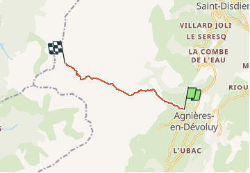

Length
6.4 km

Max alt
2249 m

Uphill gradient
939 m
Km-Effort
15.9 km

Min alt
1336 m

Downhill gradient
34 m
Boucle
No
Creation date :
2019-05-18 17:20:38.916
Updated on :
2019-05-18 17:20:38.916

FREE GPS app for hiking
 SityTrail
IGN / Geographical institutes
SityTrail Plus
The world is yours!
About
Trail of 6.4 km to be discovered at Provence-Alpes-Côte d'Azur, Hautes-Alpes, Le Dévoluy. This trail is proposed by oliviergau.
Positioning
Country:
France
Region :
Provence-Alpes-Côte d'Azur
Department/Province :
Hautes-Alpes
Municipality :
Le Dévoluy
Location:
Agnières-en-Dévoluy
Start:(Dec)
Start:(UTM)
727850 ; 4953448 (31T) N.
Comments